ASPECTS OF LUXULYAN PARISH
Hazel Harradence.
Luxulyan Parish covers approximately 12 miles from the A30 trunk road at Innis in the north to almost the A390 in the south. From east to west it varies between 2 and 4 miles. The local pronunciation is ‘Lux ill yan’. There have been many spellings over the years, but the earliest seems to be ‘Lossulyan’ in 1412, similar to the Breton place-name.
The main natural features are the Luxulyan valley with its huge granite boulders and the large expanses of moorland, such as Conce, Menedew and Treskilling. The moors provided a minimal income for local people who spent time streaming tin, often during the winter when farming was at its quietest; this can be seen from the occupations given in the parish registers at the various seasons.
The surface granite was used for many years, building homes, cattle sheds & barns and later quarries supplied the large dressed blocks taken to many parts of the world for building projects. At Lower Greadow there is the largest free-standing rock in Europe; it measures 49 x 27 feet and is 72 feet in girth. Another large stone nearby is known as the Sugar Loaf rock, and on the opposite side of the valley there is Will Luke’s Hat. A slightly different form of stone is the Luxillianite found in only a couple of locations. The largest piece at Trevanny became the tomb for the Duke of Wellington, in St Paul’s Cathedral.
Castilly Henge, near Innis, is an oval earthwork consisting of a central flat area surrounded by a ditch and an external bank with a causeway across the ditch leading to a single entrance. This central area measures 97 feet by 161 feet and was possibly used as an auditorium in the Late Neolithic or Early Bronze Age, suggesting that a considerable population dwelt within a few miles. The henge also lies at the centre of several prehistoric track ways, north to south and east to west.). It was used more recently as a medieval theatre and for defence during the Civil War.
There were five barrows nearby, three of which virtually disappeared when Castle Hill Farm house was built and another with the new A391 road in 1976. This last was inspected at the time of the road works but no dating evidence or burial was found, suggesting it fulfilled a ritual function.
Prideaux Castle, pronounced ‘Pridix’, although the spelling suggested to Tonkin that it meant ‘near water’. Early documents spell it as ‘Pridics’ so like a lot of places, the spelling has nothing to do with its origins. The Castle is an earthwork dating from the Iron Age. Three ramparts remain with part of a fourth and at one time was on cliffs almost 400 feet high, above the sea that came as far as Ponts Mill.
Stone Age axe heads were found at Bodiggo, Castilly (now in Bodmin Museum) and Atwell. A Bronze Age palstave was found at Colcerrow, and although on the edge of the Luxulyan Valley, it is outside of the parish. Bronze and Stone Age cauldrons were found at Broadwater, close to Treskilling Moor in 1792 having been about 28 feet below the surface. One was in good condition, although the second one found about 9 feet away was quite badly damaged, a piece of it that had broken off showed a loop that would have taken a ring handle The northern part of the parish yielded two iron-rimmed wooden shovels from the 17th and 18th centuries, one of which is now in Truro museum.
The Domesday book mentioned two manors; Bodwitgie, which included Menedew, Chenethro, Cross, Bodwen and Lockengate was the largest, having land for 7 ploughs, 5 of which belonged to the villagers, 9 slaves, 10 villagers and 22 smallholders. Trevillyn, much smaller, contained 2 ploughs, 1 villager and 3 smallholders. The manors of Rescoll, Luxulyan (by 1696) Prideaux and Gready came later. Joseph Polsue wrote that the manor of Prideaux was in existence at the time of the Conquest, but this was not so according to the Phillimore publication.
The Church, not in its present form but as the chapel of the mother church at Lanlivery, was first mentioned in 1162. The current church building mainly dates from the 15th century. We have a Communion cup and plate from 1576, now residing in Truro museum and a pair of chairs, one of which has the date 1623 carved into its back. The communion table has 1709 carved on it, although the table is reputed to have come from Lostwithiel. The shaft of the sundial in the churchyard has the date of 1687, although the top was replaced in 1902. The gateposts to the lower churchyard entrance have also been engraved: R S M P 1647. No more has been found about these last two items.
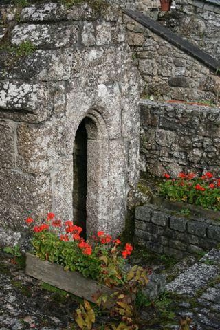
St Cyors Well
A medieval strip field system could once be seen on Treskilling Downs, although now covered in bracken. That is if the scramble motorbikes a few years ago did not manage to obliterate what remained.
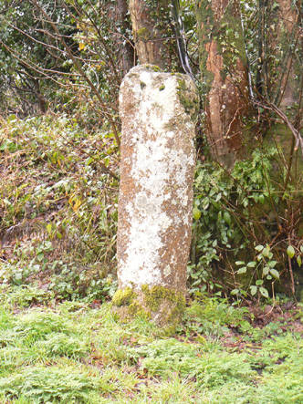
Of stone crosses, a cross at Conce Moor was removed in the mid-19th century to an adjoining farm to be used as a gatepost. It does not appear to have been seen since! The Three Stiles cross, found by Rev RG Grylls, who was vicar 1813-1853, on the Bodmin road, was removed from the vicarage grounds in 1890 and placed on the wall outside the tower entrance to the church. The base is Luxullianite. The Methrose Cross was moved to Menabilly by the Rashleigh family in 1890. The Trevellan Cross found in 1903 in a hedge was erected on the A391 at Lockengate crossroads in 1972, having first been put in the grounds of the Mission Chapel at Lockengate. The Tregonning crosshead found in 1988 in a hedge was erected nearby on the Saints Way and re-dedicated in 1993.
The Saints Way is a fictitious journey of the stuff that legends are made. It is a representation of one of the many routes taken by pilgrims and saints as they crossed Cornwall, consisting of ancient footpaths across the County from Padstow to Fowey, with stretches of roadway and tracks joining the gaps. A wonderful concept that brings tourists from all over the world, keeping the stories of our saints alive.
Old corn or grist mills start with a document of 1424 for Relythian or Relidden Mill, later Bridges Mill, possibly also known as Doga (pronounced Dugga) Mill. For Luxulyan Corn Mill, later Gattys Mill, documentation starts in 1558; the mill was destroyed in 1875 to make way for the steam railway. Much later came Rock Mill, Wood Mill, Lestoon Mill and Ponts Mill. Although some houses and fields of that hamlet were in Luxulyan parish, Ponts Mill itself was in Lanlivery. There was also a bone mill at Lower Menedew.
We have 17th century buildings at Trevillyn, Trenince, Conce, Bodwen, Medros, Methrose, Prideaux and Bodiggo; these are all listed, but there are several others of a similar age. Gunwen Farm was the birthplace of William Bryant, later O’Bryan, in 1778; the first Gunwen Chapel was built by William O’Bryan about 1796. At Little Prideaux Farm Joseph Polsue was born in 1813. He wrote Lakes Parochial History in the 1840s, a book much consulted by historians even today. Wesley stayed at Medross and held meetings there in 1755, 1762 and 1768. At Lower Greadow there are the remains of a monastic house formerly belonging to Tywardreath Priory. There are two listed shell grottos both dating from about 1780; originally in the vicarage grounds, now each of them in the gardens of houses built on either side.
The old vicarage built 1815-1836, now known as King’s Acre, was thought to have completely replaced that mentioned in a Terrier of 1680. Just recently it was discovered that part of that old building might still be visible to the rear of the current building. Unfortunately the walls have no foundations, they have been built up much higher and are not attached to the 1815 re-vamp. They are now leaning to such an extent that they will probably be demolished with the agreement of English Heritage.
This is just an overview of the early history of the parish, and there is more to be found for those who wish to take it further.
- Bousfield & Bousfield, West Cornwall Field Club, 1953-4.
- Sandra Hooper, Cornish Archaeological Society, 1976.
- Tin in Antiquity, Roger Penhallurick, 1986.
- Lakes Parochial History, Joseph Polsue, 1867-73.
- Stone Crosses in Mid Cornwall, Andrew Langdon, 1994.
- A Short History of Luxulyan Parish and the Parish Church, Dr John Rowe.
- A Short Guide to Luxulyan Parish, Donald Hawken.